
For more on the book itself, visit the publisher’s website.
This page serves as a forum in which I provide updated and additional information germane to the content of my 2022 book, Chicago in Stone and Clay: A Guide to the Windy City’s Architectural Geology, henceforth abbreviated CSC.
Please keep in mind that there’s also a lot of additional supplementary material and images pertinent to CSC and Chicago architectural geology can be found at my Flickr account. It’s best accessed from my “Wiggers Museum of Natural History” page.
News on the Book (most recent events at top)
- March 7, 2025. Added my Item 10, below, on the slightly revised geologic age of the Mondariz Granite on 2 Prudential Plaza.
- June 2, 2024: Added my Lexicon of Building-Stone Names to this website. This section, originally intended as an appendix in my Stone and Clay Series books, is offered here as a free additional resource for readers.
- May 26, 2024: Updated my Lectures and Tours pages detailing CSC-related events I’m now offering.
- October 16, 2023: CSC honored with the Geoscience Information Society’s “Best Popular Geology Guidebook” Award for 2023.
- August 14, 2023: Thanks to the Indian Trails Public Library of Wheeling, IL for hosting my virtual talk on CSC.
- December 16, 2022: The Chicago Reader designates CSC one of “The Ten Best Chicago Books of 2022” —the only nonfiction work so honored.
- November 23, 2022: John E. Riutta’s online review of CSC in The Well-read Naturalist.
- October 25, 2022: Thanks to the Evanston History Center for hosting my virtual talk on the newly released CSC.
- October 13, 2022: Thanks to the Glessner House Museum and the Friends of the Historic Second Church for hosting my virtual talk on the newly released CSC.
- August 2022: CSC is now available!
- April 7, 2022: Thanks to the Schaumburg, IL Public Library for hosting my pre-release virtual talk on CSC.
Updates and Errata
Overview. Like its sister sciences, geology is constantly in the process of revision. This can be the bane of the natural-history writer, whose job it is to convey currently held scientific understanding and prevailing ideas in a way that will not seem too confusing or intimidating to the general public—but who also has the obligation to be as accurate as possible.
However, the information the author relays often changes somewhat over the years, as specialists conduct additional research that either confirms or overturns preexisting hypotheses and accepted assumptions. As the geologist Robert Folk wrote in his classic work on sedimentary petrology, “None of the statements herein are to be regarded as final; many ideas held valid as recently as two years ago are now known to be false. Such is the penalty of research.” Never was a wiser word written.
The following items, which range from corrected typos and scientific updates to additional commentary on already accurate information, should be of special interest to architectural docents and students. Check back for new entries periodically.
Item 1. In chapter 1 of CSC I wrote, tongue firmly planted in cheek, that “the Author Is Not Responsible for Any Missing Buildings or Portions Thereof.”
Nevertheless, I note with deep regret the disappearance of one of my featured buildings already. Only a few weeks after CSC was published, I learned that site 11.16, the Antioch Missionary Baptist Church in the Englewood neighborhood, had recently burned to the ground. This beautiful fieldstone house of worship must be mourned by all true lovers of Chicago architecture.
 Requiescat in pace. © Raymond Wiggers
Item 2. On CSC‘s p. 273 (Site 17.1; George M. Pullman Monument): the final burial-pit measurement should be 9 feet wide, and not 7, for corrected overall dimensions of 8 x 13 x 9 feet.
Item 3. Site 7.6, p. 107, bottom line: change “Grant City” to Grant Park.”
Item 4. Index, p. 320: the “Liesegand rings” entry should be “Liesegang rings.” I’ve been writing about them for years, but here, somehow, a typo crept in.
Item 5. Chapter 3, p. 19, second full paragraph: in “dolostone variously quarried from the Racine, Sugar Run, and Kankakee Formations in Illinois”: change “Kankakee” to “Joliet.” It is the Joliet Formation—and especially its uppermost Romeo Member—that like the Sugar Run and Racine has a clearly documented history of use as building stone.
Ironically, the Kankakee Formation, which underlies the Joliet, may have been quarried for building stone, too. But after researching this issue further for my upcoming suburbs book, I’ve concluded that the evidence for that is just too sketchy.
Item 6. A Meditation on the MCR.
One of the most fascinating aspects of North America’s history is what happened to this continent about 1.1 Ga ago, very late in the Mesoproterozoic era. It was then that the Midcontinent Rift (MCR) formed. A titanic horseshoe-shaped breach in the crust, the MCR apparently extended from at least Oklahoma up through Minnesota, and back down through Michigan’s Lower Peninsula to Alabama.
While it is now buried far below the surface in most of its inferred range, the MCR is well exposed in the Lake Superior region. There we find vast quantities of mafic lava that erupted when the rift was young, as well as massive clastic sedimentary rock formations that were deposited after the eruptive phases had ended. It was from the latter that quarriers extracted Lake Superior Brownstone varieties for the building-stone trade (see Item 7, below),
For a science writer, this kind of dramatic and even cataclysmic event makes for catchy narrative. But it’s also a very slippery fish to get hold of. How exactly the MCR evolved, and what the timing of its various phases were, are still matters of intense debate among specialists. In CSC, with its limited permitted word count and its emphasis on architectural geology, I could only touch briefly upon the MCR’s significance and history. (See for example, sites 5.18, 9.6, and 11.6). Here, however, I can go into a little more detail. And I’ll do so, step by step:
I. It’s generally thought that the rift was a product of a major episode of regional crustal extension. In other words, the continent’s midsection was stretched apart and thinned to the extent that deep-seated magma could rise to and erupt on the surface.
II. The interesting thing about this is that the late Mesoproterozoic was also the time of the Grenville Orogeny, one manifestation of the assembly of the supercontinent Rodinia. The Grenville was not just one mountain-building event, but a succession of at least three episodes that occurred hundreds of miles to what is now the east of the Lake Superior area. These pulses of continental compression were caused by the collision of ancestral North America (Laurentia) and various other landmasses.
III. Apparently the MCR formed in a time of extension between these compressional events. How exactly did that work? And there’s another nagging question: was the MCR just a passive rift, caused by mere crustal stretching, or was it also an active rift, fed by a mantle plume rising to the surface to form a hot spot? If it was only passive, why was so much lava—over 7 miles deep—erupted into it? On the other hand, wouldn’t it have been an awfully big coincidence if this part of Laurentia had just happened to ride over an eruptive hot spot while there was passive rifting causing eruption, too? Needless to say, various researchers have proposed various models based on various types of evidence. No surprise there.
IV. After the rifting had ceased, layers of clastic sedimentary rocks (the Bayfield Group in Wisconsin and similar units in Minnesota; the Jacobsville Sandstone in Michigan) were deposited atop the lava deposits that occupied the down-dropped trench. I’ll have more to say about these Lake Superior Brownstones in Item 7, below.
V. But that’s not the end of it. At some point after 1.1 Ga ago, the great trench was inverted. In other words, this region experienced crustal compression that pushed the trench’s contents thousands of feet upward along reverse faults. (A great place to see this is Michigan’s Keweenaw Peninsula, where one of those faults runs right up its spine.) It seems to make sense that this compression and inversion occurred during one or both of the final two Grenville phases (the Ottawan and the Rigolet). This, as I understand it, was the conclusion of a 2022 paper by Hodgin et al. (“Final inversion of the Midcontinent Rift during the Rigolet Phase of the Grenvillian Orogeny”). But some other MCR experts have averred that the inversion occurred not then, but long after the Grenville. Oy vey!
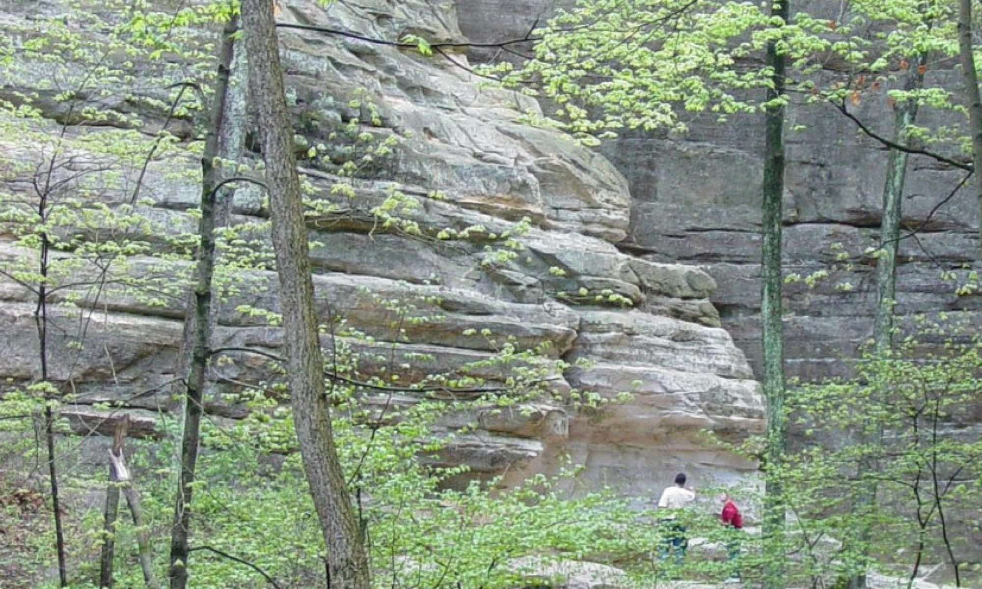
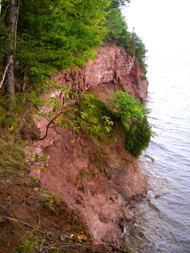
 A wee glimpse of the Midcontinent Rift’s copious supply of basalt. This outcrop is on the northern Lake Superior shore of the Keweenaw Peninsula, at Esrey Park, near Eagle Harbor. It’s an extrusive mafic rock mapped as the Volcanic Member of the Copper Harbor Conglomerate. But local geologists call it the “Lake Shore Traps.” I will expound on the Swedish origin of “traps”‘ and “traprock” at some later time. © Raymond Wiggers
Item 7. A Meditation on the Lake Superior Brownstones. In CSC I describe several members of the Lake Superior Brownstone (LSB) family, including the “Portage Red” and ‘Raindrop” varieties of Michigan’s Jacobsville Sandstone, and Wisconsin’s Chequamegon Sandstone. See, for example. sites 9.6, 11.6, 14.12, and 14.13.
In these accounts I note that for a long time geologists have been unsure of the age of the Chequamegon and Jacobsville formations—that estimates have ranged from latest Mesoproterozoic era, not long after the Midcontinent Rift formed, to the early Cambrian period, some 600 Ma later. And periodically I add that my own best guess is that they’re Neoproterozoic.
It turns out that my hunch was pretty good. In researching my third book of this series, Chicago Suburbs in Stone and Clay, I’ve come across a flurry of recent journal articles that report their teams’ latest geochronological analyses in the Midcontinent Rift area. Most of these have used the wondrous (wondrous to me, at least) detrital-zircon method, which establishes MDAs—maximum depositional ages—of LSB units.
Once the MDA of a rock unit is established, you know that it must be at least a smidgeon younger than that. After all, what you’ve actually determined is the age of the zircon crystals embedded in the sandstone. And those crystals originated somewhere else, at some earlier time. So what you still don’t know is how much younger than that the rock really is. If you’re lucky, you’ll find some other line of evidence that helps you with the lower age boundary. But if you don’t, all you can say is, “This unit is younger than XXX Ma.”
If you read the journal articles I cite above in chronological order, you’ll see there been a general trend from low-probability MDAs to those of a higher probability. I’m no geochronologist, but I assume this is a function of improving dating technology and improved experimental technique. Both the machines are the human beings are getting their act together, more and more.
I may have missed a report or two. If you think I have, please let me know. But from culling the numbers I’ve found so far, I have come up with these dates for the following LSB units:
Wisconsin’s Bayfield Group
- Orienta Sandstone: younger than 1059 Ma = 1.059 Ga = possibly super-late Mesoproterozoic, but more likely early Neoproterozoic.
- Chequamegon Sandstone: younger than 1035 Ma = 1,035 Ga = possibly super-late Mesoproterozoic, but more likely early Neoproterozoic.
Minnesota
- Hinckley Sandstone (discussed not in CSC but prominently featured in Milwaukee in Stone and Clay): younger than 1010 Ma = 1.01 Ga = possibly super-super-late Mesoproterozoic, but more likely early Neoproterozoic.
Michigan
- Jacobsville Sandstone: younger than 993 Ma; older than 986 Ma. = early Neoproterozoic.
For the Jacobsville, the lower boundary was taken from calcite-fill veins in Keweenaw Fault breccia, which were determined to post-date the sandstone formation. Pretty nifty, eh? But keep in mind that the MDA for the Jacobsville comes from its upper layers. So its bottom section, which was deposited earlier, is somewhat older.
At any rate, that’s what I’ve been able to cull from the literature so far. If you are a geologist who knows I’ve missed something, please let me know.
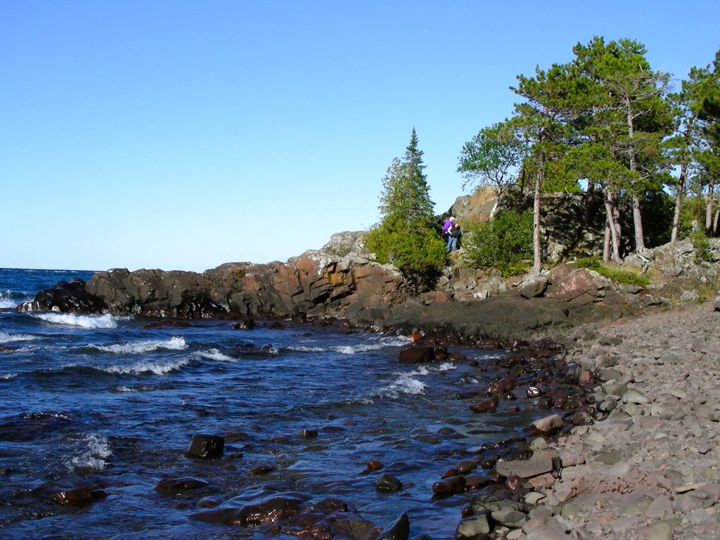
 The Jacobsville Sandstone in its native habitat, along the Lake Superior shore, Presque Isle Park, Marquette, Michigan. Here it sits unconformably atop an Archean-eon rock mapped as “serpentinized peridotite.” In other words, it’s ultramafic rock more characteristic of the upper mantle than the crust, that was subsequently metamorphosed by contact with seawater. © Raymond Wiggers
Item 8. And for all you Lake Superior Brownstone fans:
The correct pronunciation of the Chequamegon Sandstone is NOT shuh-KWA-muh-gun. It’s shuh-WAH-muh-gun.
Don’t ask me why. I don’t know. There is no logic to this. I just ask the locals.
But, while we’re at it, let’s have a preview of two stone types featured in my upcoming Chicago Suburbs in Stone and Clay:
Shawangunk Conglomerate (from New York State): pronounced SHON-gum.
Seisholtzville Granodiorite (from South Mountain, Pennsylvania): pronounced SEE-sholtz-vul.
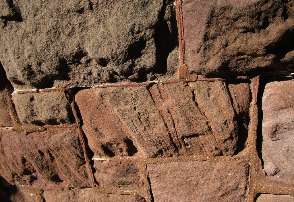 Crossbedded Shu-WAH-muh-gun Sandstone used as ashlar on the Forest Home Cemetery Chapel, Milwaukee. Also note the beaded, color-coordinated mortar.© Raymond Wiggers
Item 9. Chicagoland Spit Chronological Update. As mentioned above, keeping track of all the new research into the timing of the various tectonic episodes of the Midcontinent Rift is a pain. But it’s not as difficult as staying current with the seemingly endless chronology revisions of late-Pleistocene events in northeastern Illinois.
Whatever one writes about glacial advances and retreats, highstands and lowstands of Lakes Chicago and Michigan, and the ages of Chicagoland spits is destined to be wrong within a few years.
For the descriptions of the Wilmette, Rosehill, and Graceland Spits in CSC‘s sites 17.1 and 18.2, I used a previously impeccable Illinois State Geological Survey (ISGS) source authored by that agency’s expert in Chicago’s Quaternary geology. Based on that, I cited in CSC the following ages for the spits:
Wilmette (formed during the Glenwood I& II highstands): ca. 14.5-12.2 ka
Rosehill (formed during the Calumet highstand): 11.8-11.2 ka
Graceland (formed during Nipissing I & II highstands): 5-4 ka.
However, in my research for my series’ third book, Chicago Suburbs in Stone and Clay, I’ve come across quite a collection of recently published research papers and geologic maps, and even one thesis, on this subject. They all have one thing in common: they report dates for the items cited above that have been pushed back considerably from what I had been using.
Unfortunately, none of their corrections exactly match one another. This is even true of ISGS maps in the same series published just a year apart! There are valid scientific reasons for this. While there can be several types of evidence to draw on—radiocarbon analysis, pollen and other plant remains, the study of shoreline features with lidar, and so forth—human interpretation still plays a role. So different researchers come up with somewhat different numbers.
For the time being I’ve tried my best to synthesize a reasonable updated chronology, based on latest peer-reviews sources. Here it is. I’m sure it will need to be tweaked further as time goes on.
Wilmette (formed during the Glenwood I& II highstands): ca. 16.8-15.1 ka
Rosehill (formed during the Calumet highstand): ca. 14.2-13.1 ka
Graceland (formed during what is now considered the sole Nipissing highstand): ca. 6.1-4.5 ka.
Please note that all the ranges cited above are dates before present and not radiocarbon years.
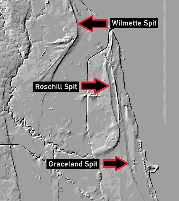 A lidar map of Chicago’s North Side and Near North Suburbs. I have annotated the spits discussed above. Also visible are the North Branch of the Chicago River, the North Shore Channel, and the elevated METRA tracks running through Evanston. Lidar imagery courtesy of the US National Map, maintained by the US Geological Survey
Item 10. In section 5.8 of CSC, which is my description of “Two Pru,” the Postmodernist skyscraper 2 Prudential Plaza, I list Spanish Mondariz Granite as its main exterior stone type.
In my initial research on the Mondariz, I found only one source, a technical treatise on European building stone, that cited its geologic age. It indicated that this granite formed during the early, Carboniferous-period portion of the Variscan (or Hercynian) Orogeny. This great mountain-building event was part of the assembly of the supercontinent Pangaea.
Much more recently, and almost three years after the publication of CSC, I’ve come across a more geologically rigorous description of the Mondariz issued by the Eurolithos, a consortium of European geologic surveys and academic institutions. This source states that the Mondariz Granite actually dates from very late in the Carboniferous (Late Pennsylvanian, in American geologic terminology) to the Cisularian epoch of the Permian Period.
So, whenever I get around to describing this handsome rock type in print again, I’ll cite it as “late Upper Carboniferous to Lower Permian.” It’s a slight emendation, but as always I’m trying my best to be as accurate as possible.